Masterprosjekt vår 2019 ved GEO - Isabelle Lecomte
Convolution modelling of georadar images - application to outcrop models of paleokarsts
Hovedinnhold
Project description
The project is linked to the FOPAK project (FOrecating architecture, seismic characteristics and flow behaviour in PAleoKarst reservoirs) – a cross disciplinary collaboration between Uni Research, UiB and NORSAR, funded by the Research Council of Norway (RCN). Further
cooperation with the University of Strasbourg is established for the georadar expertise.
http://uni.no/en/uni-cipr/geosciences/fopak-forecasting-of-architecture-...
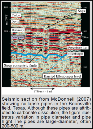
Reservoirs consisting of karstified rocks and collapsed cave systems (paleokarst reservoirs) are characterized by complex geometries. Outcrop analogues of such complex structures can be used to better understand images produced by geophysical methods, in particular for seismic exploration. But performing seismic acquisition and imaging for outcrops is difficult. An alternative is to use Ground-Penetrating Radar (GPR – georadar), which is another wave- propagation method, but using electromagnetic (EM) waves instead of elastic ones. EM- waves do not react to the same properties as the elastic ones, but the overall principles of acquisition, processing and imaging is very similar to seismic. Modelling georadar sections from outcrop structures and comparing with actual data may help better constraining imaging issues faced by seismic on paleokarst reservoirs, especially resolution and illumination effects. A proper scaling can be applied to relate seismic and georadar imaging, as done in earlier studies. The main aim of the present project is to test a convolution modelling developed for seismic and used for outcrop modelling, to simulate georadar images instead.
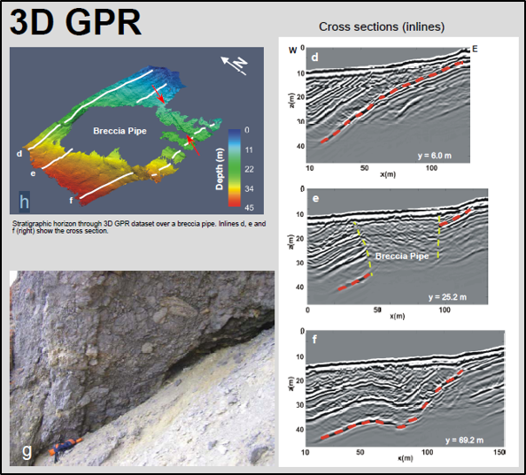
The available reference data set come from the Wordiekammen plateau in the Carboniferous Billefjorden half-graben basin on Spitsbergen, where cliffs bounding the plateau expose breccia pipes. On the plateau top, the collapse pipes are obscured by thick scree, thus km- scale size and spacing data for the pipes and faults were collected in 2011 by mapping the bedrock with 2D GPR. Two pipes were further studied in 3D using high-resolution GPR, seismic tomography and electrical methods. These geophysical data were merged into a comprehensive 3D framework including helicopter-borne lidar and photo scans of the plateau rim geology, thus allowing an integrated visualization and interpretation of the different datasets. Breccia bodies were then identified by steep-sided zones of complex diffraction patterns interrupting bedding-related continuous reflections. Such structures will then be modelled by the convolution modelling mentioned earlier as an application test.
https://en.wikipedia.org/wiki/Ground-penetrating_radar
Hypothesis
The main aim of the proposed project is to adapt and test a convolution modelling developed
for seismic and already used for various outcrop modelling of complex geological features,
this to simulate georadar sections instead. The real georadar data will serve as a reference
because corresponding to observable structures on the studied outcrops.
Work
The convolution modelling approach will first be adapted and tested on synthetic models
provided by the FOPAK project, this using existing software and based on established
equivalences between seismic and georadar. A specific study point (literature study) will be
the definition of the proper georadar properties (dielectric constant) to use in the models. The
convolution modelling will then be applied to the outcrop models of the Wordiekammen
plateau, in comparison to the existing georadar sections.
Prerequesites
geofysikk (geologisk eller matematisk retning)
Proposed course plan during the master degree
Gjøres etter avtale med veileder, vil avhenge av studentens bakgrunn og interesse, men følgende emner er anbefalt:
- PTEK218 - Rock Physics (10 sp)
- GEOV219 - Computational methods in solid earth physics (10 sp)
- GEOV274 - Reservoir Geophysics (10 sp)
- GEOV300 - Selected Topics in Geoscience (5 sp)
- GEOV375 - Advanced Applied Seismic Analysis (10 sp)
- UNIS AG-335 – Arctic Seismic Exploration (10 sp)
- Spesialpensum om georadar (undervises ikke på GEO) (5 sp)


