A study of normal fault structure and along-strike variations, based on the northern Moab fault system, Utah

Hovedinnhold
Project description
The background is the complexities of faults and fault zones and how they vary laterally. The aim is to understand this better through the following activities:
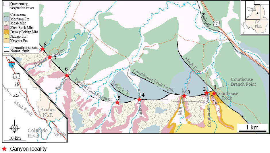
1) To describe a normal fault with 100-150 m offset in detail and construct a series of sections by collecting data from exposed canyon walls that cross the fault. There are 8 canyons (numbered in the map) that provide exposures through the fault, some being more complete than the others. A profile from both canyon walls can be made in most (but not all) cases, exceptions being Canyon numbers 5 and 1.
2) Investigate how fault-related features change along strike and discuss this in light of fault growth and make connections to seismic imaging of faults (resolution). Specifically, the result would be useful as an example of subseismic to near-seismic resolution structure/geometry varies along normal faults in silisiclastic sedimentary sequences, including reservoir-type sandstone.
3) Contribute to the production of seismic model (synthetic seismic line) along two of the sections, in collaboration with a student that focuses more on seismic modeling (separately announced master project). These two students should work together on this part.
Deformation structures ranging from km-scale down to deformation bands and potentially microscale structures will be included. The structure of the fault zone will be described. Damage zone, fault core, type of deformation structures (deformation bands, shear fractures, extension fractures). Structure frequency profiles will be collected, and variations in these with lithology is easy to demonstrate at these locations. Fault lens development, fault splays as well as hanging-wall drag occur and vary along the fault. The fault core itself, however, is usually not exposed.
Field data collection: Photogrammetry, drone imagery, field pictures combined with Clino/FieldMove measurements of structures and mapping on field photos. Very limited rock sampling is necessary. The data will be linked to thin sections and permeability measurements already collected.
Background data:
Satellite image (low-res version below), GoogleEarth, data from publications, permeability data and thin-sections from main advisor’s data base.
Proposed course plan during the master's degree (60 ECTS):
GEOV352 (5 sp) Field course in reservoir geology
GEOV300 (5) Selected topics in geoscience
GEOV251 (10) Advanced structural geology
GEOV260 (10) Petroleum geology
GEOV272 (10) Seismic interpretation
SDG207 (10) Energy transition
GMG5826 (10) Global tectonics (7.5 UiB sp)
GMG5827 (5) Special topics in structural geology (3.75 UiB sp)
Field- lab- og analysis
ca. 3 weeks of field work in Utah, USA; Structural mapping.
Student
Lucas Correa
Supervisors
Professor Haakon Fossen
Associate Professor Isabelle Lecomte
Professor Atle Rotevatn