Drilling in the Right Direction
20.06.2008 Rock layers form complex three dimensional shapes that beneath the surface of the earth can be sloping, folded and thicken and thin.

Hovedinnhold
Careful mapping has been made of the orientation and distribution of different rock types found in cliffs and river beds of the Barberton Mnt Land to understand what the rocks are doing below ground. This was a crucial planning stage to the Barberton Scientific Drilling Project to locate the best sites to drill.
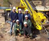
On site the drill rig is carefully oriented in a direction perpendicular to geological bedding and structural contacts. This photo shows the initial site establishment phase involving towing of the drill rig to the site and careful positioning and orientation of the rig to the nearest cm. This step is a crucial part of the drillling exercise as it determines how soon the target rock horizons will be reached and at what angle and depth the hole should be drilled.