Mapping and analyses of lateral meltwater channels in the Norwegian mountains as a method of determining the thinning rate of the Scandinavian Ice Sheet
Main content
Project description
The main objective is to gain new knowledge about the deglaciation history and interaction with climate. This includes the extent, thickness and dynamics of the Scandinavian Ice Sheet and the relation to past climatic changes. A good knowledge of processes and their causal connections is a prerequisite for making reliable predictions of the ice sheet response on Greenland and Antarctica in response o the ongoing global warming. This will require new and precise geological and geomorphological data that can be used for making detailed reconstructions of the changing ice sheet configuration. In this project, it is the intention to study lateral meltwater channels in the Norwegian mountains and associated glacial geological feature that formed along the edge of the Scandinavian Ice Sheet. These features, that mirror the surface of the ice sheet when they formed, will be utilized to reconstruct the changing ice sheet configuration and rate of thinning.
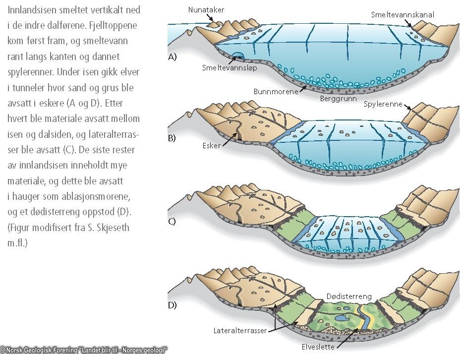
Existing data indicate that even the highest mountains were ice covered during the Last Glacial Maximum (LGM) some 20,000 years ago, when the ice sheet it was flowing due west independent of the underlying topography. As the ice sheet became smaller and thinner, the ice movement gradually became controlled by the substrate, but it would take 10,000 yrs before all the ice had melted and there is still significant uncertainty associated with the course of deglaciation. Lateral moraines of Younger Dryas age (12,800-11,600 yrs BP), a time when the Scandinavian Ice Sheet was the size of the Greenland Ice Sheet, can be followed from the valley Sunndalen in NW Norway and up to an elevation of 1200-1300 m a.s.l. along Drivdalen towards the mountain massif Dovrefjell. Both above and below the ice surface that correspond to this glacial stage, hundreds of lateral meltwater channels can at places be seen along the mountain slopes and with a fairly regular height intervals (1-2 m) between the individual steps. This regularity give reason to suspect that they reflect annual lowering of the ice surface. In that case, this will provide unique data sets to quantify the rate ice sheet thinning.
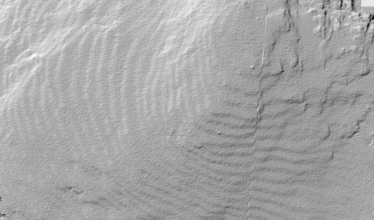
In this master project it is the intention to map, date and analyse series of lateral drainage channels and related glacial features in selected mountain areas in Southern Norway. (Sunndalsfjella-Dovrefjell-Oppdal-Rondane). The basis for the mapping work will be high-resolution digital terrain models (DMT) from airborn LIDAR measurements combined with aerial photograhies and field studies. This mean that GIS also must be used as a tool in the surveys. It may also be relevant to use other methods, including drones and so-called machine learning to help mapping with the potential to study other areas. In order to link the floating chronology for the mapped drainage channels with 14C ages it is desirable to core lake basins in corresponding height intervals. It is an advantage, but not a prerequisite that two students collaborate on the project.
Proposed course plan during the master's degree (60 ECTS):
GEOV205 - Geographical information systems_Theory and practises
GEOV222 - Palaeoclimatology,
GEOV225 - Field course in Quaternary Geology and palaeocliatologu,
GEOV226 - Field and lab course in Quaternary geology,
GEOV229 - Geomorphology
GEOV326 - Quaternary environment, processes and development
Field- lab- and analysis
In this master project it is the intention to map, date and analyse series of lateral drainage channels and related glacial features in selected mountain areas in Southern Norway. (Sunndalsfjella-Dovrefjell-Oppdal-Rondane). The basis for the mapping work will be high-resolution digital terrain models (DMT) from airborn LIDAR measurements combined with aerial photograhies and field studies. This mean that GIS also must be used as a tool in the surveys. It may also be relevant to use other methods, including drones and so-called machine learning to help mapping with the potential to study other areas. In order to link the floating chronology for the mapped drainage channels with 14C ages it is desirable to core lake basins in corresponding height intervals. It is an advantage, but not a prerequisite that two students collaborate on the project.
Supervisors
John Inge Svendsen
Ben Robson